Protecting the UK’s coasts
What is coastal erosion?
Erosion is the physical removal of land by the sea. The two main mechanisms that drive erosion are wave motion, which is generated by wind; and mean currents beneath the surface of the waves, which are created by waves and tides. These waves and currents in the near-shore region move sediments from one location to another.
As sea levels rise because of climate change, the area affected by erosion will move further inland. Meanwhile, it is thought warming will result in heavier rain and more frequent flash floods. Flooding of coastal areas is connected to (and hastens) coastal erosion.
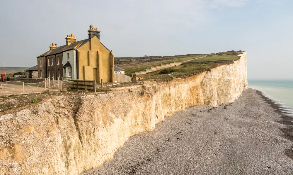
About 28% of English and Welsh coastline is vulnerable to erosion, with 6% losing more than a metre of land each year. Communities across the country are under threat, but the east of England is particularly vulnerable because of the largely softer sediments making up the coastline. Norfolk villages Happisburgh and Hemsby, which face out to the North Sea, have between them lost over 50 homes to erosion during a 20 year period, forcing residents to relocate.
Climate change is only making matters worse, with rising sea levels and stronger storm activity speeding up rates of erosion. According to research by climate action group One Home, if no action is taken, 21 villages and hamlets will be lost to coastal erosion by 2100, representing £584 million worth of residential property. In many cases, residents are not compensated for losing their homes, and may even have to pay thousands towards the cost of demolition. So, how are engineers working to protect the country’s coasts?
What can cause coastal erosion?
- Coastal erosion is a natural process, influenced by factors including sea-level rise because of climate change, and subsidence, or sinking land
- Subsidence can be down to human activities such as groundwater or oil and gas extraction, and natural processes, such as the Earth’s continued adjustment to the last ice age
- The latter is a major factor for the UK and has caused our east coast to continually sink relative to the sea. As a result, the coastline is eroding to find an equilibrium
Soft versus hard engineering
Approaches to reducing coastal erosion can be split into two categories: hard and soft engineering.
Hard engineering involves building structures to reduce energy transport from the ocean to the coast, such as sea walls, groynes, and rock armour. Soft engineering tends to use natural resources such as sand or vegetation, and often harnesses the forces of nature.
Interventions to coastal erosion have historically involved hard engineering. However, it’s now recognised that these solutions disrupt natural coastal dynamics, and can, for instance, increase erosion further down the coast, effectively moving the problem elsewhere. With a greater understanding of the dynamics of coastal areas, we now – when possible, and appropriate – tend to opt for a softer approach.
"There’s definitely a strong move to soft, and working with sediment,” says Robert Nicholls, professor of climate adaptation at the University of East Anglia and director of the Tyndall Centre for Climate Change Research. “It’s flexible, it can adjust to changing conditions – it has multiple benefits.”
However, he notes: “With any response, it’s not forever. It’s for a period of time.”
With any response, it's not forever. It's for a period of time.
Robert Nicholls, professor of climate adaptation at the University of East Anglia and director of the Tyndall Centre for Climate Change Research
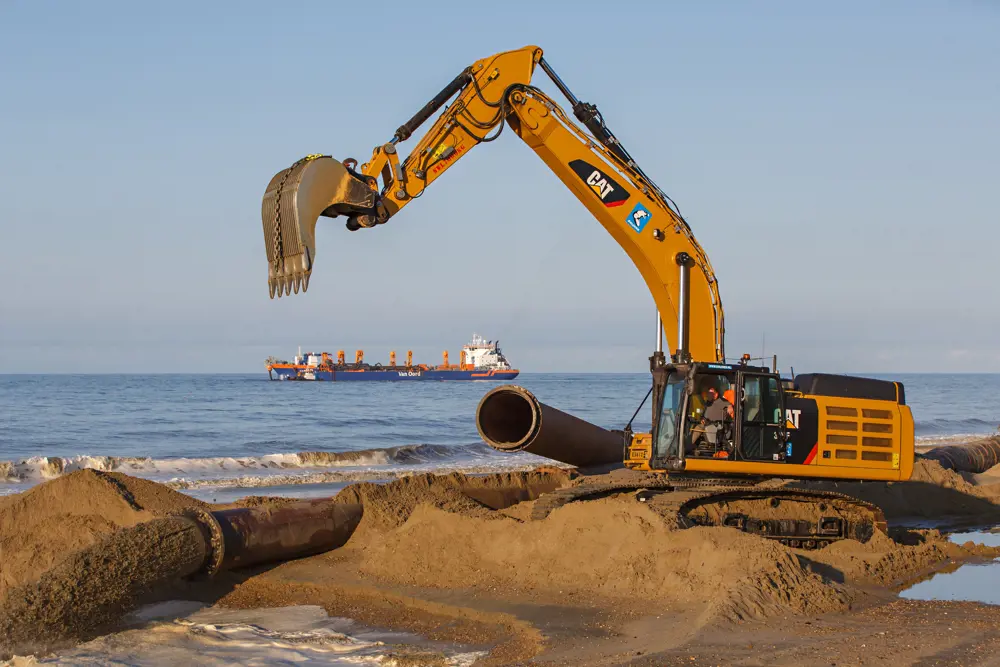
One such technique, sand nourishment, is where large volumes of sand – traditionally hundreds of thousands of cubic metres – are deposited on strategic points on the shore to keep beaches topped up with sediment. It is also called ‘sandscaping’ (typically when done on a larger scale and when designed to harness the prevailing forces of nature).
Nourishments can be a more environmentally sound alternative to hard coastal defences, if they are designed to work with the forces of nature. This means that wind, waves, and currents redistribute the sand gradually, which avoids disruptive changes to beach habitats.
Nourishments can adapt to rising sea levels, and do not simply move erosion further along the coast. As they are, in effect, widening the beach, they can restore or create habitats for the flora and fauna that make the coast their home. Hard defences, built to prevent cliff erosion, can exacerbate the problem they were brought in to solve. After nourishment, the new sediment replaces the sand that would have been released by the eroding cliff.
With traditional nourishments, the sand must be replaced each spring. However, new approaches to nourishment are making the intervention more efficient and long lasting.
Where is the sand coming from, and how can we collect it sustainably?
Sand can be dredged from the sea floor, extracted from inland sites or ‘recycled’ from spots where it has accumulated near the shore. Unfortunately, some of these methods of extraction, as well as the transport and placing of the material needed for beach nourishment, can have an impact on the local environment. Habitats can be destroyed at extraction sites and take decades to recover, while the activity of dredging itself can disturb marine animals.
In the UK, sand for both nourishments and construction is sourced from areas on the seabed that have been selected for suitability and to ensure limited impacts to the environment, says Jaap Flikweert from Royal HaskoningDHV. This process includes performing a special environmental impact assessment (EIA), which is required by UK legislation for any activities that could significantly impact marine environments.
Nicholas Dodd, professor of coastal dynamics at the University of Nottingham, is working on such approaches with his team. For instance, some involve dumping the sand further offshore in an area called the shoreface – where the seafloor slopes downward from the beach.
“These big shoreface nourishments would slowly move onshore, under natural processes,” says Dodd. “It’s a very, very gradual process, much less dramatic than during a storm.”
Shoreface nourishments were first carried out in the Netherlands in the early 1990s as a proactive rather than reactive approach to coastline protection. Compared with beach nourishments, they are longer lasting, generally cheaper, and avoid inconvenience on the beach.
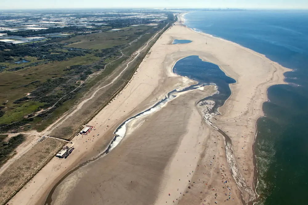
“The Dutch have a particular interest in protecting their coastline,” says Dodd. Over 250 kilometres of the Dutch coastline is protected by sand dunes – damage to which can cause disastrous floods. So, they didn’t stop at the shoreface. In 2011, Dutch engineers built De Zandmotor (‘sand motor’), an artificial peninsula near the Hague.
Aiming to protect nearby dune systems for 20 years, they dumped 21.5 million cubic metres of sand along the coast. A nourishment on this scale is also called a ‘sand engine’ or ‘mega nourishment’. (For context, the O2 in London has a total volume of 2.2 million cubic metres.)
The UK's first sand engine
How Royal HaskoningDHV's sand engine is protecting Norfolk's coastline
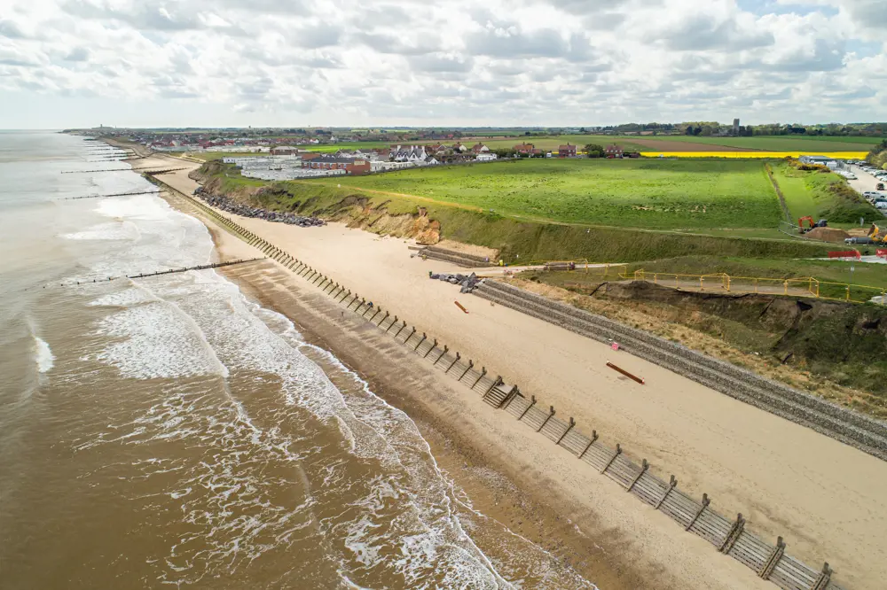
In December 2013, a storm surge battered north Norfolk and removed 10 metres of coast in three days. It left the Bacton Gas Terminal a mere 15 metres from the sea and caused severe flooding in neighbouring villages. To protect the terminal and the nearby villages of Bacton and Walcott, Dutch engineering consultant Royal HaskoningDHV were brought in to design a solution.
Having worked on the Zandmotor project, Royal HaskoningDHV created the UK’s first sand engine. In 2019, about 1.8 million cubic metres of sand were placed on the beaches flanked by Bacton, Walcott and the Bacton Gas Terminal, to absorb the energy transferred by the sea before it reaches the cliffs and the villages’ flood defences.
Two years after the sand was placed, analysis showed that the scheme is working broadly as planned, and is expected to last for 15 to 20 years. Ongoing research has found that the scheme has prevented at least one flood event, helped the local economy by improving the beaches, and reduced worry among those who live in the area.
“You’ve deposited so much sand that it changes the behaviour of the waves,” explains Dodd. “The idea is [to] alter the direction in and intensity with which the waves and currents move the sand and therefore possibly alleviate erosion.”
With the long-term protection afforded by sand engines, councils save on the cost of renourishing each year. “Over the course of time, the waves will naturally spread that enormous quantity of sand that has been deposited there along the coast,” says Dodd. In the case of De Zandmotor, it’s now thought it will provide protection for much longer than 20 years.
A 2021 study into the effectiveness of sand nourishments in the Netherlands over the past three decades concluded that all types of nourishments combined have successfully maintained the position of the country’s 432 kilometres of coastline.
In recent years, local councils in the UK and their partners have followed suit, depositing drastically increased volumes of sand. The UK’s first sand engine, placed in north Norfolk in 2019, continues to protect thousands of people living in the villages of Bacton and Walcott, as well as the Bacton Gas Terminal, which supplies a third of the UK’s gas (see box ‘The UK’s first sand engine’).

A model solution
To help design their coastal defences, whether hard or soft, engineers use computer-based numerical models to simulate real shoreline processes.
Numerical modellers select appropriate equations to simulate how coastal systems behave, and then solve the equations using specific techniques. No one model can describe an entire coastal system: rather, engineers simulate processes at different time and length scales. Engineers can then conduct experiments using those models to understand how a system might evolve with or without an intervention.
For example, engineers at Imperial College London used numerical simulation to determine how a breakwater structure comprising 20-tonne concrete units would fare against stormy seas.
Numerical models help engineers design the defences that will perform the best in certain locations, and do so within budget. “Much of the work that we would do in beach nourishment is develop numerical models that improve our ability to simulate how the nourishment will behave,” says Dodd. “We ideally want to know what the intervention will do.”
How accurately can models reproduce real processes? “That’s an ongoing area of research,” says Dodd. “There’s always a trade-off between the complexity of the model – the amount of physics that the model would include – and how long you could run that model for over one spatial scale,” he says.
To enable these simulations, engineers must use abstracted models. This means that, for example, if you wanted to simulate cliff retreat along the English coast over the course of 1,000 years, rather than simulating the effects of individual waves, you would aggregate the effects of those waves.
Harnessing the insights produced by numerical modelling and making them easier to digest can also make decisions easier for councils. In a former role as an engineer in consultancy, Jack Heslop (now senior research associate at the Tyndall Centre for Climate Change Research), helped councils make decisions about where to invest in their flooding and coastal erosion defences.
With one tool, which brought together mapping, economic and flooding data, Cornwall Council could visualise at street level the cost of potential damage resulting from adverse weather events and coastal erosion, providing an evidence base for their investment.
Today, the numerical modelling Heslop (working with Nicholls) is developing is on a much larger scale. Their project aims to understand the impact of sea-level rise on humanity, focusing on the behaviour of the Greenland and Antarctic ice shelves. It is generating sea-level projections to 2500, which they are synthesising with global human population modelling to understand the implications for people under different scenarios such as if we stick to the Paris agreement, continue our reliance on fossil fuels, or somewhere in between.
The long game
Erosion is an eternal problem for our island nation. What other tools and technologies are engineers and researchers currently working on to protect our coasts?
Nature-based solutions are gaining traction. For example, planting sea grasses can help stabilise offshore beach nourishments. Similarly, restoring oyster reefs and kelp beds provides another natural defence from erosion. Engineers are even exploring how bacteria can make beach sand more cohesive, and thus less easily eroded.
Along with the range of engineering approaches in our arsenal, we may need a cultural change in how we see our coastlines, not as fixed lines but as transient spaces.
However, along with the range of engineering approaches in our arsenal, we may need a cultural change in how we see our coastlines, not as fixed lines but as transient spaces.
While we have many ways to manage erosion in the short term, over generational timescales, sea-level rise will eventually make defending some coastal settlements unviable. The government has acknowledged this in recent policy documents and by funding the Coastal Transition Accelerator Programme (CTAP). Focusing on North Norfolk and the east riding of Yorkshire, this aims to ensure coastal communities are supported through these transitions through proactive engagement and action.
For system-wide changes, the slower the change can happen, the less disruptive it will be. Hence, slowing future sea-level rise by mitigating climate change today is the best way to give future coastal communities the time to respond and adapt.
***
This article has been adapted from "Protecting the UK's coasts", which originally appeared in the print edition of Ingenia 96 (September 2023).
Contributors
Nicholas Dodd is professor of coastal dynamics at the University of Nottingham’s civil engineering department. His research focuses on numerical modelling of beach change because of both natural processes and human interventions.
Robert Nicholls is director of the Tyndall Centre for Climate Change Research at the University of East Anglia and professor of climate adaptation, and previously led coastal engineering at the University of Southampton. Much of his work has focused on sea-level rise and climate change.
Jack Heslop is a senior research associate at the Tyndall Centre for Climate Change Research studying the long-term impacts of sea-level rise on global coastal communities. Previously, Jack worked in engineering consultancy for seven years.
Leonie Mercedes
Author
Keep up-to-date with Ingenia for free
SubscribeRelated content
Environment & sustainability
Recycling household waste
The percentage of waste recycled in the UK has risen rapidly over the past 20 years, thanks to breakthroughs in the way waste is processed. Find out about what happens to household waste and recent technological developments in the UK.

Upgrade existing buildings to reduce emissions
Much of the UK’s existing buildings predate modern energy standards. Patrick Bellew of Atelier Ten, a company that pioneered environmental innovations, suggests that a National Infrastructure Project is needed to tackle waste and inefficiency.

An appetite for oil
The Gobbler boat’s compact and lightweight dimensions coupled with complex oil-skimming technology provide a safer and more effective way of containing and cleaning up oil spills, both in harbour and at sea.

Future-proofing the next generation of wind turbine blades
Before deploying new equipment in an offshore environment, testing is vital and can reduce the time and cost of manufacturing longer blades. Replicating the harsh conditions within the confines of a test hall requires access to specialist, purpose-built facilities.
Other content from Ingenia
Quick read

- Environment & sustainability
- Opinion
A young engineer’s perspective on the good, the bad and the ugly of COP27

- Environment & sustainability
- Issue 95
How do we pay for net zero technologies?
Quick read

- Transport
- Mechanical
- How I got here
Electrifying trains and STEMAZING outreach

- Civil & structural
- Environment & sustainability
- Issue 95